Since the release of the James Cameron blockbuster film Titanic, photographers, tourists, and adventurers have been migrating to the eastern coast of Canada in a quest to view and photograph icebergs. Most all will return home never having seen one of these icy monoliths and that is a shame; with a minimum amount of research it is possible to fill hard drives with pictures rather than pockets with postcards.
Newfoundland and Labrador, Canada’s easternmost province, continues to be the most easily accessible location in the world to photograph icebergs. Yet, the birth and journey of a North-Atlantic iceberg began approximately 12,000 – 3000 years earlier along the western coast of Greenland, and its 100 or so glaciers.
As the glacier reaches its terminus along the shores of the West Greenland Sea, the continual scrubbing and scouring of waves and tidal action will break off huge slabs of the glacier in a process known as calving and ultimately result with the birth of an iceberg. From the major glaciers between the Jakobshavn and Humbolt ice fields it is estimated that upwards of 30,000 icebergs will be calved annually, yet slightly less than 500 icebergs will eventually reach the Grand Banks off eastern Newfoundland. It is also important to understand that nearly all of the icebergs that reach the Atlantic Ocean will have been calved along the west coast of Greenland and generally follow the same briny route.
Once the newborn iceberg settles into the West Greenland Current it will be edged westward toward Baffin Bay, south through the Davis Strait and into the open waters of the Labrador Sea. The counter-clockwise estuarine circulation of the frigid Labrador Sea will push the southward bound iceberg past Baffin Island and along the shores of mainland Labrador until it eventually reaches the St. Anthony area and the northern coast of Newfoundland. It is somewhat ironic that the incubation of an iceberg has taken a minimum of 3000 years, the journey south to Newfoundland about three years, and its death mere months—if not weeks—once it journeys south of 48 degrees north latitude.
Each degree of latitude translates to 60 nautical miles, and by reviewing the iceberg activity chart available from Environment Canada a little more closely, we will see that St. John’s, Newfoundland’s capital city, lies at about 47° 40’ (or 20 miles south of the 48th parallel). Therefore we can ascertain that our search for bergs should traverse no further south than this self-proclaimed oldest city in North America. Should we continue studying the chart we will notice that St. Anthony lies approximately four degrees further to the north, or about 240 nautical miles. Although this distance might appear at first glance to be quite insignificant, it is a huge leap in improving the likelihood of iceberg sightings.
While I consider St. Anthony to be the best location to photograph icebergs it does require some effort to get there. The village of Twillingate, on the other hand, can be equally as profitable and unquestionably the most easily accessible. Located slightly more than a one-hour drive north of the central Newfoundland town of Gander, the village has several tour boat operators who specialize in iceberg watching. Twillingate is a small fishing town with several hotels and unique Bed & Breakfast accommodations whose proprietors are quite familiar and responsive to a photographer’s (unusual) requirements. In addition, Gander is the home of an international airport with connecting flights to a wide variety of air carriers, and the usual deluge of car rental companies. Consequently it is possible to be in contact with a tour boat operator in Twillingate one day and be there making photographs the next from anywhere in North America.
Like most things in life, given the opportunity to rehearse and practice we should eventually get the task done properly. However, icebergs don’t offer many opportunities—relatively speaking—and for many photographers it is a one-shot deal. Therefore it would be prudent to study the photographs of icebergs that appeal to us to learn what the quality of that particular image is. The act of making the picture should then be an exercise of learned skill and not mere luck.
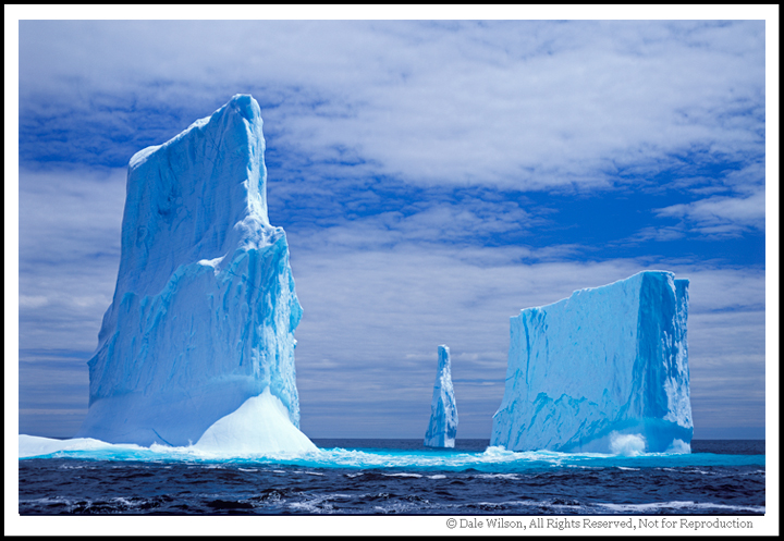
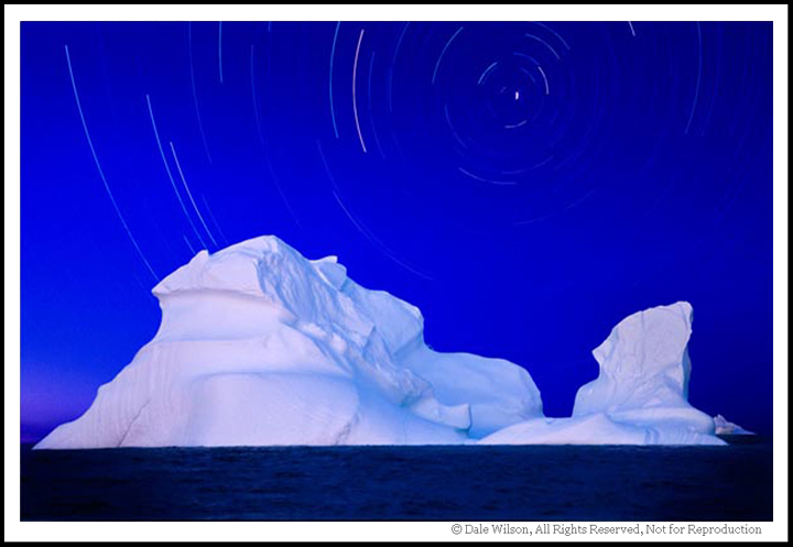
Think of an iceberg as a building. Should you photograph that building and its vertical rise in the generally preferred light of early morning and late afternoon the image will be somewhat ‘flat’ due to the lack of shadows rendered from frontal lighting. Conversely, if you were to re-photograph the same scene between mid-morning and mid-afternoon when the sun was higher in the sky, shadows should be thrown across the building façade and thereby create textural detail. The iceberg is no different, and this same approach will render an image with the desired blueness and textural crispness that sends the message of coldness and purity that brings oooh’s and aaah’s at any AV show.
Do your research and by having the necessary flexibility to get north when the icebergs are moving through, you too should have that euphoric experience of seeing and successfully photographing your first iceberg.
URL Resources:
Marine charts: http://ice-glaces.ec.gc.ca
Satellite imagery: http://www.icebergfinder.com


Some Older Comments